
The Great Caucasian Wall
The Great Caucasian Wall
This city has more than twenty names and its main landmarks are included in the UNESCO World Heritage List.
It still holds many unsolved mysteries and can rightfully be considered the cultural capital of Dagestan. Naturally, we are talking about Derbent, so unique and inimitable.
In 2015, Derbent celebrated its 2,000th anniversary with great pomp, but this was a celebration of a city, while human life in Derbent began at least 5,000 years ago, in the distant Bronze Age. Over five millennia, Derbent has seen much and more. It has been claimed by the Roman empire and the Parthian kingdom, Iran and Byzantium, the Arab caliphate and the Khazar khaganate, the Seljuk empire and the Golden Horde, the Persian shahs and the Ottoman sultans. Its walls were stormed by such renowned commanders as Maslama ibn Abdulmalik and Marwan ibn Muhammad, the Seljuks Sau-Tegin and Yagma, Genghis Khan’s chief military leaders Subudai and Jebe,and the Asian conquerors Tamerlane and Tokhtamysh.
What is Derbent’s greatness, and why is it called the Great Wall of the Caucasus?
Derbent’s glory and, at the same time, tragedy was ensured by its geographic location. The city was founded on the narrowest stretch of flat land between the Caucasus Mountains and the Caspian Sea. The three-kilometre-long isthmus connecting land and sea determined Derbent’s future destiny, making it a magnet eagerly to which world powers and their rulers were drawn. What makes Derbent so unique and why did the Arab traveler Zakaria al-Qazwini, who visited Derbent in the 13th century, call it a marvel?
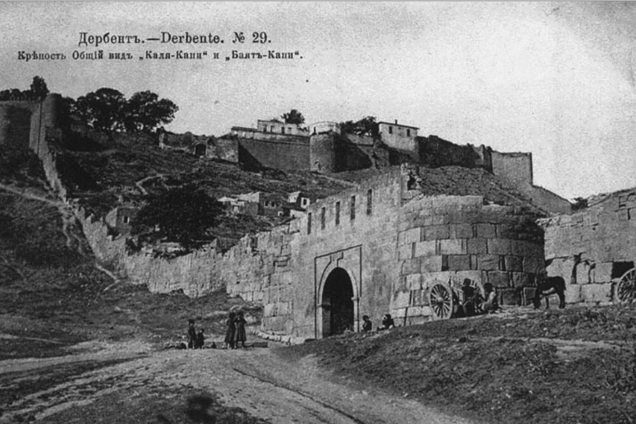
It all stems from Derbent’s defenses, eventually consisting of a powerful fortification complex of the Naryn-Kala citadel, fortress walls that completely enclose the city on both sides and sea walls. There is also the Dag-Bary Mountain wall, which extends more than 40 kilometres into the mountains, preventing enemy attacks from entering Derbent by flanking routes. The Dag-Bary Mountain wall, many kilometres long, evokes associations with the Great Wall of China.
The Naryn-Kala citadel was a secure refuge for the ruler and his numerous retainers. It served as a palace, located on a hill, which not only offered an excellent view of the city but also made it virtually impregnable. After Derbent was captured by tsarist troops in 1806, a military garrison was stationed at Naryn-Kala. According to archaeologist Vladimir Markovin, signal fires, familiar to Dagestan and the entire Caucasus, were also lit on this “khan’s” hill. During an enemy invasion, these signal fires served as a distress signal, a kind of Morse code. According to Zakariya al-Qazwini, signal fires were also lit higher up, on the mountaintop. For these purposes, “every year, despite shortages, large quantities of firewood were collected to light fires. In this way, the residents of Arran (a region in Transcaucasia), Azerbaijan, and Armenia to the south were warned of an enemy advance.”
The two parallel fortress walls extending from the Naryn-Kala citadel and reaching down into the sea deserve special mention and admiration. Until the mid-19th century, the city of Derbent occupied only this rather narrow space between the walls. Today, Derbent is spread out and the second largest city in Dagestan by area but in ancient times, the inhabitants of Derbent lived between the two walls. This was done for the city’s defense and to repel the influx of nomads into the fertile lands of Transcaucasia and Iran. During the Great Migration Period, this became more relevant than ever. Derbent served as a man-made barrier, an outpost and a buffer zone separating sedentary peoples from nomads. This was the concept of the first architects and builders of Derbent’s existing stone walls – the Sassanid rulers, Kavad I and Khosrow Anushirvan I. The stonework replaced another wall, a mudbrick one, which also closed the so-called Derbent Pass.
The existing construction was completed in the second half of the sixth century, during a break in the Persian-Byzantine War. The sheer scale of the military fortifications could not fail to attract all sorts of traders, travelers, and scholars. Blocks over a metre thick, walls 18–20 metres high and 3.5 metres wide. The seventeenth century German traveler, Adam Olearius, estimated that one could ride a cart along the Derbent wall. Zakariya al-Qazwini accurately determined the length of the fortress walls (two-thirds of a farsakh) and measured the width using a unique Eastern method – the flight of a released arrow. The Russian traveler Ivan Berezin counted 455 paces between the walls. The aforementioned Adam Olearius calculated five paces less. This discrepancy is not surprising. Near the sea, the walls had a maximum width of 450 meters, while near the citadel, they narrowed to 350 meters. In addition to the northern and southern walls, the fortress was also enclosed by transverse walls. The first of these shielded the khan’s palace from prying eyes. The remaining walls divided the city into several segments, the last of which led to gardens and the sea coast.
During Zakaria al-Qazwini’s stay in Derbent in the thirteenth century, the city boasted strong Muslim traditions, despite the fact that Islam had not yet fully established itself in Dagestan (“Land of Mountains”). After walking along the city walls, al-Qazwini recorded Derbent’s Islamic outline in his notes thus: “It (the fortress) has many towers and in each tower there is a mosque for passersby and those engaged in religious studies.” Zakaria al-Qazwini also describes another mosque located outside Derbent: “Outside the city there is a hill on which a mosque is erected. In its mihrab is a sabre. It is said that it belonged to Maslama ibn Abdulmalik ibn Marwan. This place is visited exclusively in white robes.” Maslama’s probable sabre takes us back to Maslama himself, during whose reign the Arabs, and with them Islam, first established themselves in Derbent. It was then, in 734, that the oldest Juma mosque in what is now Russia was built. Derbent became one of the centers of Islam’s spread in Dagestan. In this sense, Derbent lives up to its Arabic name – Bab al-Abwab (“gate of gates”).
After the establishment of Islam, Derbent acquired a new identity in its glorious centuries-long history – as a major religious and scholarly centre, attracting prominent scholars of the Muslim East. Derbent became a place of study and training. Its numerous mosques became schools of popular and higher education. Abu Bakr al-Darbandi, a renowned Sufi scholar of the late eleventh and early twelfth centuries, noted in his essays that theologians invited from other parts of the caliphate held lectures in the Derbent Juma Mosque. Yaqut al-Hamawi, in his encyclopedia, Mu’jam al-Buldan, cites several prominent scholars associated with Derbent. Among them is Zuhayr ibn Nu’aym al-Babi. Episodes from his life are recounted in Abu Nu’aym al-Isfahani’s renowned multi-volume work, Hilat al-Awliya. Derbent’s scholarly wealth and significance in the Islamic world are also evidenced by the fact that, at the request of Derbent residents, the founder of the Ash’ari madhhab, Abu al-Hasan al-Ash’ari, wrote an entire treatise on religious belief. This treatise is called “Risala ila Ahl al-Sagr bi Bab al-Abwab” and is an exposition of the Sunni faith.
And today, as throughout the centuries and millennia, Derbent has not lost its special appeal and oriental flavour. It continues to write its own history, a history yet to be completed.
